


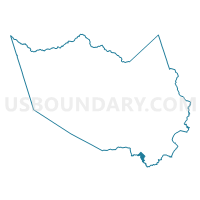
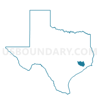
Voting District 0474, Harris County, Texas
About
Outline

Summary
| Unique Area Identifier | 673884 |
| Name | Voting District 0474 |
| County | Harris County |
| State | Texas |
| Area (square miles) | 2.91 |
| Land Area (square miles) | 2.88 |
| Water Area (square miles) | 0.03 |
| % of Land Area | 99.07 |
| % of Water Area | 0.93 |
| Latitude of the Internal Point | 29.55266230 |
| Longtitude of the Internal Point | -95.19295300 |
Maps

Graphs
Select a template below for downloading or customizing gragh for Voting District 0474, Harris County, Texas


Neighbors
Neighoring Voting District (by Name) Neighboring Voting District on the Map
- Voting District 0051, Brazoria County, TX
- Voting District 0378, Harris County, TX
- Voting District 0456, Galveston County, TX
- Voting District 0475, Harris County, TX
- Voting District 0485, Galveston County, TX
- Voting District 0537, Harris County, TX
- Voting District 0545, Harris County, TX
- Voting District 0655, Harris County, TX
- Voting District 0782, Harris County, TX
Top 10 Neighboring County Subdivision (by Population) Neighboring County Subdivision on the Map
- Houston CCD, Harris County, TX (3,075,388)
- Texas City-League City CCD, Galveston County, TX (217,765)
- Alvin-Pearland CCD, Brazoria County, TX (176,301)
Top 10 Neighboring Place (by Population) Neighboring Place on the Map
Top 10 Neighboring Unified School District (by Population) Neighboring Unified School District on the Map
- Clear Creek Independent School District, TX (210,500)
- Pearland Independent School District, TX (93,154)
- Friendswood Independent School District, TX (25,524)
Top 10 Neighboring State Legislative District Lower Chamber (by Population) Neighboring State Legislative District Lower Chamber on the Map
- State House District 29, TX (208,164)
- State House District 24, TX (181,472)
- State House District 129, TX (150,798)
Top 10 Neighboring State Legislative District Upper Chamber (by Population) Neighboring State Legislative District Upper Chamber on the Map
Top 10 Neighboring 111th Congressional District (by Population) Neighboring 111th Congressional District on the Map
Top 10 Neighboring Census Tract (by Population) Neighboring Census Tract on the Map
- Census Tract 3501, Harris County, TX (15,280)
- Census Tract 3506.02, Harris County, TX (8,714)
- Census Tract 3505, Harris County, TX (6,848)
- Census Tract 7201, Galveston County, TX (5,874)
- Census Tract 3508.01, Harris County, TX (4,855)
- Census Tract 6601, Brazoria County, TX (4,523)
- Census Tract 7202, Galveston County, TX (4,465)
- Census Tract 3506.01, Harris County, TX (4,115)
- Census Tract 3507, Harris County, TX (2,272)